
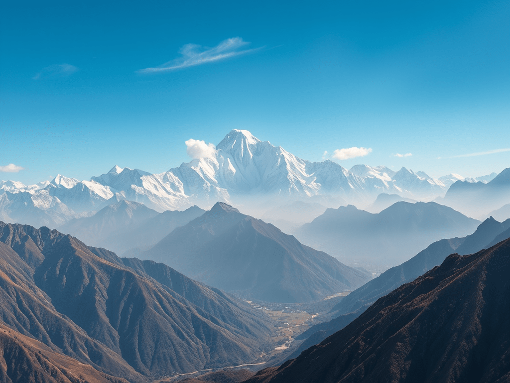
The Himalayas are a huge mountain range in northern India. They are not just tall mountains but are very important for India’s environment, culture, and safety. These notes are written in simple language for first-time learners, covering everything you need to know about the Himalayas for UPSC and BPSC exams, including their formation, types, divisions, and importance.
What Are the Himalayas?
- Definition: The Himalayas are young mountains formed when two big pieces of Earth’s crust (called tectonic plates) collided.
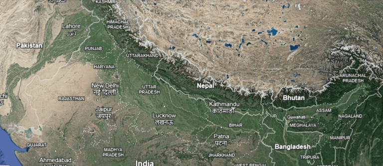
- Location: They stretch across northern India, covering states like Jammu & Kashmir, Himachal Pradesh, Uttarakhand, Sikkim, Arunachal Pradesh, and parts of West Bengal and Assam.
- Role: They act like a giant wall, protecting India from cold winds and invaders from the north. They also separate the flat Indo-Gangetic Plains (south) from the high Tibetan Plateau (north).
How Were the Himalayas Formed?
The Himalayas were created millions of years ago due to the movement of Earth’s plates. Here’s a step-by-step explanation:
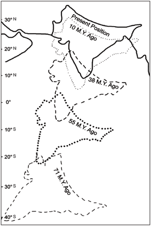
- Pangea (250 million years ago): Long ago, all continents were joined together in one supercontinent called Pangea, surrounded by a huge ocean called Panthalassa.
- Pangea Breaks (150 million years ago): Pangea split into two parts:
- Laurasia (Angaraland): Included present-day North America, Europe, and Asia.
- Gondwanaland: Included present-day South America, Africa, India, Australia, and Antarctica.
- Tethys Sea Forms: When Pangea broke, a narrow sea called the Tethys Sea formed between Laurasia and Gondwanaland, where the Himalayas are today.
- Sediments Collect: Rivers from Laurasia and Gondwanaland dumped mud, sand, and rocks (sediments) into the Tethys Sea.
- Gondwanaland and Laurasia Break Further: Gondwanaland split into smaller pieces, including the Indo-Australian Plate (India + Australia). Laurasia split into the Eurasian Plate (Europe + Asia).
- Plates Collide: The Indo-Australian Plate moved north and crashed into the Eurasian Plate across the Tethys Sea.
- Folds Form: The crash squeezed the Tethys Sea’s sediments, pushing them up to form folds (like crumpling paper).
- Himalayas Born: The Tethys Sea disappeared, and the folded sediments became the Himalayas.
- Still Growing: The plates are still pushing, so the Himalayas grow about 5 mm every year.
Exam Tip: Remember the sequence: Pangea → Tethys Sea → Plate collision → Himalayas. Draw a diagram of plates colliding for answers.
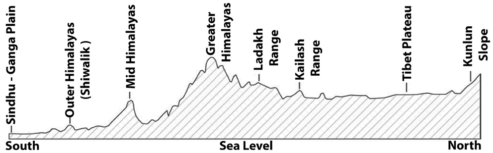
Types of Himalayas
The Himalayas are divided into four main types based on their features:
- Trans-Himalayas:
- Located north of the main Himalayas.
- Dry, high plateaus with an average height of 3,000 meters.
- Includes ranges like Karakoram, Ladakh, and Zaskar.
- Greater Himalayas (Himadri):
- The highest part with famous peaks like Mount Everest and Kanchenjunga.
- Snow-covered and very tall.
- Lesser Himalayas (Himachal):
- Middle range with rugged hills and popular hill stations like Shimla and Darjeeling.
- Height: 3,500–5,000 meters.
- Shivalik Hills:
- The lowest and youngest part, closest to the plains.
- Made of soft rocks and fertile soil.
Exam Tip: Memorize the order: Trans-Himalayas (north) → Greater Himalayas → Lesser Himalayas → Shivalik (south).
Longitudinal Divisions of the Himalayas
The Himalayas are divided into three parts based on their east-west stretch:
- Trans-Himalayas:
- North of the Greater Himalayas, stretching ~1,000 km.
- Average height: 3,000 meters.
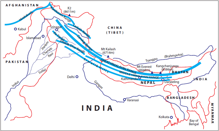
- Key Ranges:
- Karakoram Range:
- Northernmost, borders Afghanistan and China.
- Has K2 (8,611 m, world’s 2nd highest peak) and Siachen Glacier (world’s largest non-polar glacier).
- Ladakh Range:
- Southeast of Karakoram, near Indo-Tibetan border.
- Includes Deosai Mountains (in Pakistan-occupied Kashmir).
- Zaskar Range:
- Parallel to Greater Himalayas.
- Kamet Peak (7,756 m) is the highest here.
- Karakoram Range:
- Himalayan Ranges:
- Stretch ~2,400 km from Indus River (west) to Brahmaputra River (east).
- Made of sedimentary and metamorphic rocks (soft and hard rocks).
- Wider in the west, narrower in the east.
- Average height: 6,100 meters.
- Sub-Divisions:
- Greater Himalayas (Himadri):
- Highest range with ancient rocks (granite, gneiss).
- Peaks: Mount Everest (8,848 m, world’s highest), Kanchenjunga, Nanga Parbat, Namcha Barwa.
- Steep slopes on the north, gentle on the south.
- Lesser Himalayas (Himachal):
- Height: 3,500–5,000 m; width: 60–80 km.
- Ranges: Pir Panjal, Dhauladhar, Nag Tibba, Mahabharat, Mussoorie.
- Features: Kashmir Valley (between Pir Panjal and Zaskar), hill stations (Shimla, Nainital, Ranikhet), Karewas (fertile deposits for agriculture).
- Rivers: Jhelum, Chenab flow through.
- Shivalik Hills:
- Southernmost, between Lesser Himalayas and plains.
- Wider in the west; called Churia Range in Nepal.
- Features: Doons (west) and Duars (east) – fertile areas for tea cultivation.
- Formed when rivers were blocked, creating lakes that left fertile soil.
- Greater Himalayas (Himadri):
- Eastern Hills (Purvanchal):
- Low hills formed where Himalayas turn south at Dihang Gorge.
- Stretch from Arunachal Pradesh to Mizoram.
- Forms India-Myanmar border.
- Ranges:
- Patkai Bum: Northernmost, along Arunachal-Myanmar border.
- Naga Hills: South of Patkai Bum, part of India-Myanmar watershed.
- Manipur Hills: South of Naga Hills, split by Barail Range.
- Mizo (Lushai) Hills: Southernmost, in Mizoram.
Exam Tip: Practice mapping these divisions. Remember: Trans-Himalayas (north), Himalayan Ranges (middle), Purvanchal (east).
Regional Divisions of the Himalayas
The Himalayas are divided into four regions based on rivers:
- Punjab Himalayas:
- Between Indus and Sutlej rivers.
- Covers Jammu & Kashmir, Himachal Pradesh.
- Features: Karakoram, Pir Panjal, Zaskar, Dhauladhar ranges; high peaks, deep gorges.
- Kumaon Himalayas:
- Between Sutlej and Kali rivers, in Uttarakhand.
- Also called Garhwal Himalayas.
- Peaks: Nanda Devi, Trisul, Kedarnath, Badrinath.
- Hill stations: Nainital, Ranikhet, Almora.
- Nepal Himalayas:
- Between Kali and Tista rivers, mostly in Nepal.
- Peaks: Mount Everest, Kanchenjunga, Dhaulagiri.
- Features: Kathmandu Valley.
- Assam Himalayas:
- Between Tista and Brahmaputra rivers, in Assam, Arunachal Pradesh.
- Lower elevation; ranges run north-south.
- Peaks: Namcha Barwa (highest), Gyala Peri.
Exam Tip: Memorize rivers as boundaries: Indus-Sutlej (Punjab), Sutlej-Kali (Kumaon), Kali-Tista (Nepal), Tista-Brahmaputra (Assam).
Syntaxial Bends of the Himalayas
- What Are They?: The Himalayas bend sharply southward at their western and eastern ends.
- Western Syntaxial Bend:
- Near Nanga Parbat (Jammu & Kashmir).
- Indus River cuts a deep gorge here.
- Eastern Syntaxial Bend:
- Near Namcha Barwa (Arunachal Pradesh).
- Brahmaputra River marks the bend.
Exam Tip: Mention syntaxial bends in questions about Himalayan structure. Draw a diagram showing the bends.
Western vs. Eastern Himalayas: A Simple Comparison
| Feature | Western Himalayas | Eastern Himalayas |
|---|---|---|
| Location | Indus to Kali River (J&K, Himachal, Uttarakhand) | Tista to Brahmaputra (Assam, Arunachal) |
| Height | Gradual rise; peaks far from plains | Abrupt rise; peaks close to plains |
| Rainfall | Less rain (1/4th of Eastern) | Heavy rain, dense forests |
| Vegetation | Coniferous forests, alpine meadows | Evergreen, temperate, alpine forests |
| Biodiversity | Moderate | High (biodiversity hotspot) |
Exam Tip: Use this table for quick revision. Compare rainfall and biodiversity for short-answer questions.
Why Are the Himalayas Important?
- Controls Climate:
- Blocks monsoon winds, causing rain in northern India.
- Stops cold Siberian winds, keeping India warmer in winter.
- Protects India: Acts as a natural wall against invaders.
- Water Source: Gives birth to major rivers (Ganga, Indus, Brahmaputra), supporting farming and life in northern India.
- Forests: Provides timber, medicinal plants, and raw materials for industries.
- Agriculture: Terraced slopes used for growing tea, fruits, and crops.
- Minerals: Rich in copper, zinc, gold, silver, limestone, and more.
- Hydroelectricity: Fast rivers are ideal for generating electricity.
- Biodiversity: Home to unique plants and animals, vital for ecological balance.
Exam Tip: For significance, structure your answer: Climate → Security → Water → Forests → Agriculture → Minerals → Power.
Challenges Facing the Himalayas
- Climate Change: Glaciers are melting, affecting water supply.
- Deforestation: Trees cut for roads, buildings, reducing forest cover.
- Pollution: Trash from tourists and industries harms the environment.
- Too Many Tourists: Overcrowding damages hill stations and nature.
- Solution: Promote eco-friendly tourism, plant trees, and fight climate change.
Exam Tip: Link challenges to current affairs (e.g., glacier retreat, sustainable tourism) for essay questions.
Frequently Asked Questions (FAQs) for Exams
- Where are the Himalayas in India?
- Northern border, across Jammu & Kashmir, Himachal Pradesh, Uttarakhand, Sikkim, Arunachal Pradesh, West Bengal, Assam.
- What are the Himalayas?
- Young fold mountains formed by plate collision, famous for high peaks and biodiversity.
- How were the Himalayas formed?
- Indo-Australian Plate hit Eurasian Plate, folding Tethys Sea sediments into mountains.
- What’s another name for the Himalayas?
- “Abode of Snow” (Himālaya in Sanskrit) or Himadri.
- How many ranges do the Himalayas have?
- Three main ranges: Greater (Himadri), Lesser (Himachal), Shivalik. Also includes Trans-Himalayas and Purvanchal.
Exam Tip: FAQs are common in prelims and mains. Memorize short answers for quick recall.
Quick Revision Table
| Topic | Key Points |
|---|---|
| Formation | Pangea → Tethys Sea → Indo-Australian & Eurasian Plate collision → Himalayas. |
| Types | Trans-Himalayas, Greater Himalayas, Lesser Himalayas, Shivalik Hills. |
| Longitudinal Divisions | Trans-Himalayas (Karakoram, Ladakh, Zaskar), Himalayan Ranges (Himadri, Himachal, Shivalik), Purvanchal. |
| Regional Divisions | Punjab, Kumaon, Nepal, Assam Himalayas. |
| Syntaxial Bends | Western (Nanga Parbat, Indus), Eastern (Namcha Barwa, Brahmaputra). |
| Significance | Climate, security, water, forests, agriculture, minerals, hydroelectricity. |
| Challenges | Climate change, deforestation, pollution, unregulated tourism. |
CrackTarget Notes are crafted for easy understanding and quick revision, ensuring first-time learners and UPSC/BPSC aspirants master the Himalayas effortlessly. Study smart, score high!

Leave a comment